Photogrammetric 3D reconstruction has revolutionized the work flow on construction sites, the maintainance of critical infrastructure, e.g. bridges and dams, and preservation of cultural heritage. By capturing detailed three-dimensional images of structures and artifacts, this technology provides an invaluable tool for professionals in a variety of fields. From architects ensuring the integrity of aging infrastructure to archaeologists documenting ancient sites, the applications are as diverse as they are impactful.
The Challanges of 3D Reconstruction
Despite its benefits, the use of 3D reconstruction faces significant challenges, particularly when applied to cultural heritage and infrastructure maintenance. One of the main problems is the accuracy and trustworthiness of the reconstructed models. Reconstructions are often created by automated algorithms that take numerous photos as input and output a model. The easy availability of these algorithms leads some practitioners to use these tools as simple “black boxes”. Problems in the photographic material such as distortions due to lens anomalies, artifacts in the images and inconsistencies due to changing lighting conditions can lead to errors in the reconstruction process, resulting in inaccurate or distorted models as well as visual artifacts in their textures. Understanding and verifying the given reconstructions is often not possible for the end users, who ultimately have to make decisions based on the models without seeing the original images. The provenance of the reconstructions is therefore crucial for understanding the origin and history as well as the reliability of the final 3D model. Consequently, decisions made based on these reconstructions could potentially be based on erroneous information, leading to misinterpretations that could affect both historical artifacts and the safety of modern infrastructure.
Virtual Projection Planes
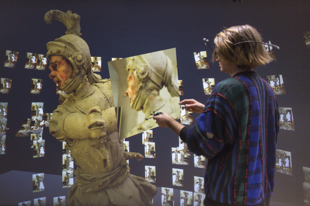
To overcome these challenges, we developed a virtual reality tool at the Bauhaus-Universität Weimar that leverages virtual projection planes. This innovative approach allows users to compare 3D models with the original photographs that generated them, facilitating a more thorough verification process. This technique offers professionals who need to rely on 3D reconstructions a new level of confidence in their accuracy.
When we developed the virtual projection planes technique, we aimed to transcend the limitations of traditional 2D user interfaces commonly used in 3D reconstruction analysis. Unlike 2D interfaces, which restrict users to flat, often oversimplified views of complex models, our VR tool allows for a more immersive and intuitive interaction with 3D reconstructions. By enabling the projection of original photographic images directly onto a 3D model within a virtual environment, users can perform a detailed, layer-by-layer comparison between the model and its photographic origins. This method not only facilitates a more accurate assessment of the model’s fidelity to the real-world object or scene but also enhances the user’s ability to detect and correct errors or inconsistencies. The virtual projection planes approach represents a significant advancement in how professionals can interact with and verify the accuracy of 3D reconstructions, offering a more nuanced and effective tool for ensuring the reliability of these digital models.
Evaluation
ur approach was evaluated through a user study involving 18 participants as well as an expert review with nine domain experts from the field of preservation of historical monuments. The study showed that the virtual projection planes enhance the ability to identify errors, making the 3D reconstruction process more transparent and reliable. The feedback from domain experts underlines the critical need for methods to ensure data fidelity, particularly for decisions where accuracy is paramount. While a certificate of data reliability is highly sought after for its promise of high reproduction quality, experts agree that the nuanced verification of subtle details in 3D reconstructions can only be assured through visual comparison. The study and the review underline the importance of tools like virtual projection planes that enable such detailed evaluations, highlighting their value in enhancing confidence in the accuracy of 3D models.
Conclusion
The development and successful evaluation of our virtual reality tool mark a significant advance in the field of 3D reconstruction. By enabling a more accurate and verifiable use of photogrammetric data, we are paving the way for safer and more informed decisions in both cultural heritage preservation and infrastructure maintenance. Our research shows that integrating original photographic data into the verification process can significantly reduce the risk of errors, ensuring that the decisions made based on these reconstructions are as accurate and reliable as possible.
Schott, E., Kulik, A., & Froehlich, B. (2020, November). Virtual Projection Planes for the Visual Comparison of Photogrammetric 3D Reconstructions with Photo Footage. In Proceedings of the 26th ACM Symposium on Virtual Reality Software and Technology (pp. 1-9).

https://doi.org/10.1145/3385956.3418956